Date: 8th June to 11th June, 2008
How to go to Taman Negara: We drive (the journey took us about 3 hours . The road from Kuala Lumpur to Temerloh is about 1.5 hours (distance about 120KM).
At the exit for Temerloh toll, we turn right to Jerantut (turn left is to take boat into Taman Negara). From the toll exit into Taman Negara is about 1.5 hours.

Make sure you have plenty of petrol in your car as not petrol station seen along the way.
Our accommodation for this trip is Woodland Resort, 
Our Taman Negara activities as explained by the resort manager:
| Day | Time | Activity |
| 8th June | 7:30 pm 8:15 pm | Dinner at Woodland Night Jungle Walk |
| 9th June | 7:30 am 9:00 am 1:00 pm 2:00 pm 7:30 pm | Breakfast at Woodland Jungle Trekking to Canopy Walkway Lunch at Woodland Rapids Shooting and visit Orang Asli Dinner at Woodland |
| 10th June | 7:30 am 9:00 am 2:00 pm 7:30 pm 8:30 pm | Breakfast at Woodland Boat to Lata Berkoh and fish sanctuary Lunch at Woodland Dinner at Jeti Night River Cruise |
| 11th June | 7:30 am 9:00 am | Breakfast at Woodland Check out |
8th June
After check in, we walk around Kuala Tahan (if you take the boat ride from Jerantut, you will reach this jetty).


After dinner, we start our night jungle walk.


Nothing much we can see as it it pitch black.
9th June
The day started very bad, my standard zoom lens cracked :(, I guess is caused by the coldness in the room and the warmness of the nature.

However, I still have my wide angle and zoom lens.


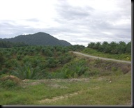
Rubber Plantation near Woodland Resort

Our ride into Taman Negara, we took the same boat as the night jungle walk into Taman Negara.


Taman Negara facing Kuala Tahan.
The walk into canopy walkway will past thru the same trail as the night jungle walk.

The water level during the 1971 (1971 Severe floods occurred in many parts of West Malaysia. A national disaster was declared on 5th January 1971. 1972 Following the damaging nation-wide flood in 1971, the DID was entrusted to undertake an extensive flood mitigation programme. Flood Mitigation and Hydrology was designated as functions of DID. Subsequent to this, dams have since been constructed, rivers canalised and drains improved to alleviate flooding in both urban and rural areas. Other measures include river diversion, river training and clearing, as well as the upkeep and management of river reserves. Telemetric flood forecasting systems were installed in Sg. Kelantan, Sg. Terengganu, Sg. Pahang, VHF flood forecasting systems installed in Sg. Batu Pahat, Sg. Muar and Sg. Kelang basins.)

From the top of the Taman Negara entrance. 


Tourist Information Centre at Taman Negara


The easy part


Our guide, Mat.


The Shampoo tree

The telephone tree


Next is the Canopy Walkway.


Canopy Walkway Ticketing Office


Distance marker (meaning you have to space 10 meter away from the person in front of you) 


Safe at last and trek back to the jetty and back to hotel for lunch.
No comments:
Post a Comment